The water vapour flux (WVF) is a vertical integral combining eastwards and northwards water vapour fluxes. This is integrated over all model levels and the average value over a specified forecast period (e.g. 24 hours) is computed using the instantaneous 6-hourly values. The units are kg m-1 s-1. Note:
- The evaluation of water vapour is essentially confined to the troposphere as there is no significant contribution from the water vapour in the stratosphere.
- The model levels follow the terrain and but recognise only broad scale structure of mountainous regions but not the detail.
- Water vapour flux shows the transport of water vapour in the atmosphere by synoptic-scale processes (e.g. extra-tropical cyclones) rather than with smaller scales.
The distribution of integrated water vapour for a given lead time does not provide useful information to aid the user and are not available as (ECMWF web service) ecCharts. It is the movement of water vapour flux that is important and these are available via (ECMWF web service) ecCharts”.
The Extreme Forecast Index (EFI) for water vapour flux compares the ensemble forecast probability distribution of an event to the M-climate distribution for the chosen location, time of year and forecast lead time. The water vapour flux EFI can provide an understanding of the synoptic-scale processes behind an extreme rainfall events.
Water vapour flux EFI complements precipitation EFI by:
- highlighting large-scale water vapour transport in the atmosphere.
- identifying extreme precipitation in the late medium-range forecast period.
The predictability of large-scale synoptic processes is higher than the predictability of smaller scale processes, particularly at longer lead times. Thus forecasts of:
- water vapour flux have large scale characteristics and imply higher predictability and greater skill.
- precipitation are linked to smaller-scale processes (e.g. with orography, cloud microphysics, etc) and have less skill.
In operational forecasting the water vapour flux EFI should be used in conjunction with the total precipitation EFI:
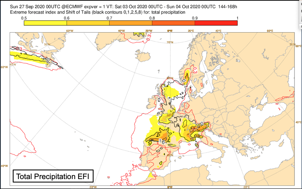
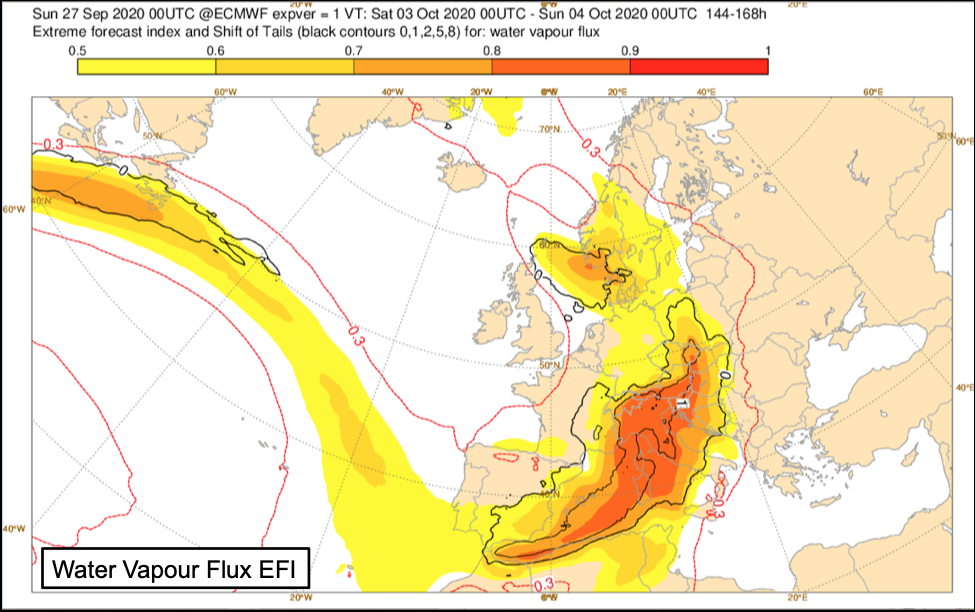
- Water vapour flux EFI tends to show up a signal earlier in the forecast than the total precipitation EFI.
- Extreme water vapour flux EFI can enable earlier awareness of extreme precipitation, and in particular early identification of the risk of flooding.
- Consideration of other factors such as orography can help interpretation of the forecasts (e.g. west coasts of continents or enhancement of orographic precipitation on windward slopes in regions of high water vapour flux EFI).
- It can be especially helpful where complex topographic details are not well captured at ensemble resolution and forecast sub-synoptic flow can result in underestimation of precipitation values and EFI on the upslope side (and overestimation on the downslope side). The broader scale flow implicit in evaluation of water vapour flux EFI gives better indication of risk areas.
- Heaviest precipitation often occurs at the edge of the area with large water vapour flux EFI.
Fig8.1.16.1: Extreme Forecast Index and Shift of Tails for Total Precipitation and Water Vapour Flux. EFI (shading) and SOT (black contours) in the forecast DT 00 UTC Monday 27 September 2020 for 24-hour period VT 00UTC 3 October to 00UTC 4 October 2020. Correspondence is evident between areas larger of Water Vapour Flux EFI and Total Precipitation EFI, particularly over Europe.
See more information on:
and article:
- in ECMWF newsletter about water vapour flux
- by David Lavers et al. published in Weather and Forecasting (doi: 10.1175/WAF-D-17-0073.1) gives more details on the evaluation of the precipitation and water vapour flux EFI across western Europe and western North America.

