Albedo
Albedo is the fraction of solar energy (shortwave radiation) reflected from the earth back into space. Where reflectivity is:
- high (high albedo) less radiation is absorbed at the earth's surface. In particular albedo is high where sea-ice is present or there is snow cover.
- low reflectivity (low albedo) more radiation is absorbed at the earth's surface. The albedo depends upon the characteristics of the underlying surface.
Albedo is determined:
- for snow-covered areas:
- at analysis time by a combination of the background climate (climatological 10-day average), satellite measurements, and observed surface fields (notably snow depth and extent).
- throughout the forecast by snow cover or ice sheets that are produced, maintained or reduced by the model. The albedo varies throughout the forecast period.
- for snow-free land areas:
- by a climatology from the MODIS satellite. This is slow to change through the forecast period.
The albedo for:
- open snow (includes snow on low vegetation) changes with age but is broadly ~0.85 for fresh snow to ~0.50 for old snow.
- forest snow (snow beneath high vegetation) depends on vegetation type. It is broadly ~0.3 just after a heavy snowfall decreasing to ~0.2 after a few days due to snowmelt (for sufficiently warm temperatures) or wind drift (for cold temperatures).
- ice depends on snow cover but varies between ~0.7 with snow and ~0.4 without snow.
- open water, lakes and sea is <0.1
Considerations
It is important to consider the effects of any day-to-day differences from model forecasts.
Important points are:
- Albedo is not modified by the diurnal variation in solar zenith angle.
- Surfaces are assumed to be horizontal so no account is taken of land orientation or slope.
- Differences in albedo that are not captured by the forecast (e.g. in mountainous areas or where observed conditions vary from forecasts).
- The albedo chart is purely climatological and anomalous conditions are not indicated.
- Widespread anomalous snowfall (increase of albedo) or snowmelt (decrease of albedo) will change the heat energy available to the varying surfaces.
- Transitory local but significant variations in surface characteristics (e.g. extensive burnt vegetation, seasonal variation in lake extent) are not represented.
- Tides can cover and uncover extensive areas of sand or mud (e.g. around the Frisian Islands) or the extent of a lake can vary substantially during the year (e.g. Lake Kati Thanda–Lake Eyre, Australia).
Temperature and consequent effects can be locally different where there are sub-grid scale variations in the forecast albedo (e.g. in 2 m temperatures or possible shower development, which in certain conditions in mountainous areas could both be more favoured over slopes facing the sun).
Additional sources of information
(Note: In older material there may be references to issues that have subsequently been addressed)
Read more on Albedo.
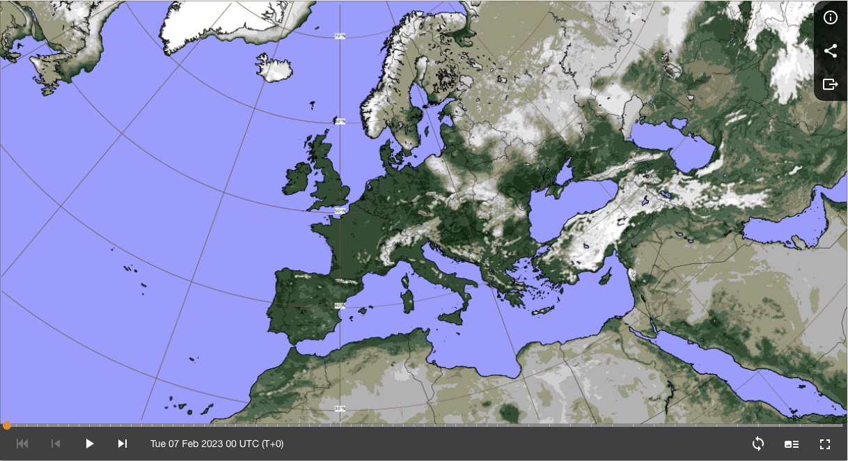
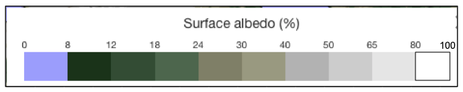
Fig2.1.18: Example surface albedo as shown in the surface parameters charts. The albedo is taken from climatological data on a monthly basis.
Solar noon is assumed when assigning model albedo values and so is probably an under-estimate of the true albedo for most of the time in daylight.
In the chart:
- darker colours indicate the greater radiation absorption qualities of vegetation.
- lighter colours indicate areas of high reflectivity (snow over mountains and Russia, and from the sands of the Sahara). Anomalous snowfall has not had an effect.
- the sea is shown blue with high absorption because it reflects back very little solar radiation.
See the current albedo chart.
Overview
Content Tools