In summer 2015 ECMWF introduced, in test mode, two new EFI parameters for forecasting severe convection - for CAPE and for CAPESHEAR - that are described below. The test period is now over, and accordingly the parameters are now included in the ECMWF real-time catalogue (see here) and are available in dissemination. In the catalogue the EFIs for CAPE and CAPESHEAR have the short names of "CAPEI" and "CAPESI" respectively. Charts based on these parameters continue to be available on the ECMWF web-site (here).
Explanation of the new parameters
While a global NWP model cannot be expected to forecast individual convective cells, such a model can tell the user whether the broadscale environment is favourable for development of deep moist convection (DMC). Based on this premise, and following user requests and extensive testing, the new EFI parameters were added to assist with the forecasting of severe convection: the EFI for CAPE and the EFI for CAPESHEAR (=CSP, for "CAPESHEAR Parameter").
- CAPE combines the effects of two of the necessary ingredients for DMC: instability and moisture. The higher the CAPE the more unstable the air mass is.
- CSP is computed according to:
where deep-layer wind shear is computed between levels l1=925 hPa and l2=500 hPa, and the second term is proportional to the maximum vertical velocity in convective updraughts as computed using simple parcel theory, i.e.:. CSP is targeted at forecasting organised DMC, such as supercell convection, as the deep-layer wind shear helps to organise convection into long-lived cells. CSP units are m2/s2 .
Practical remarks
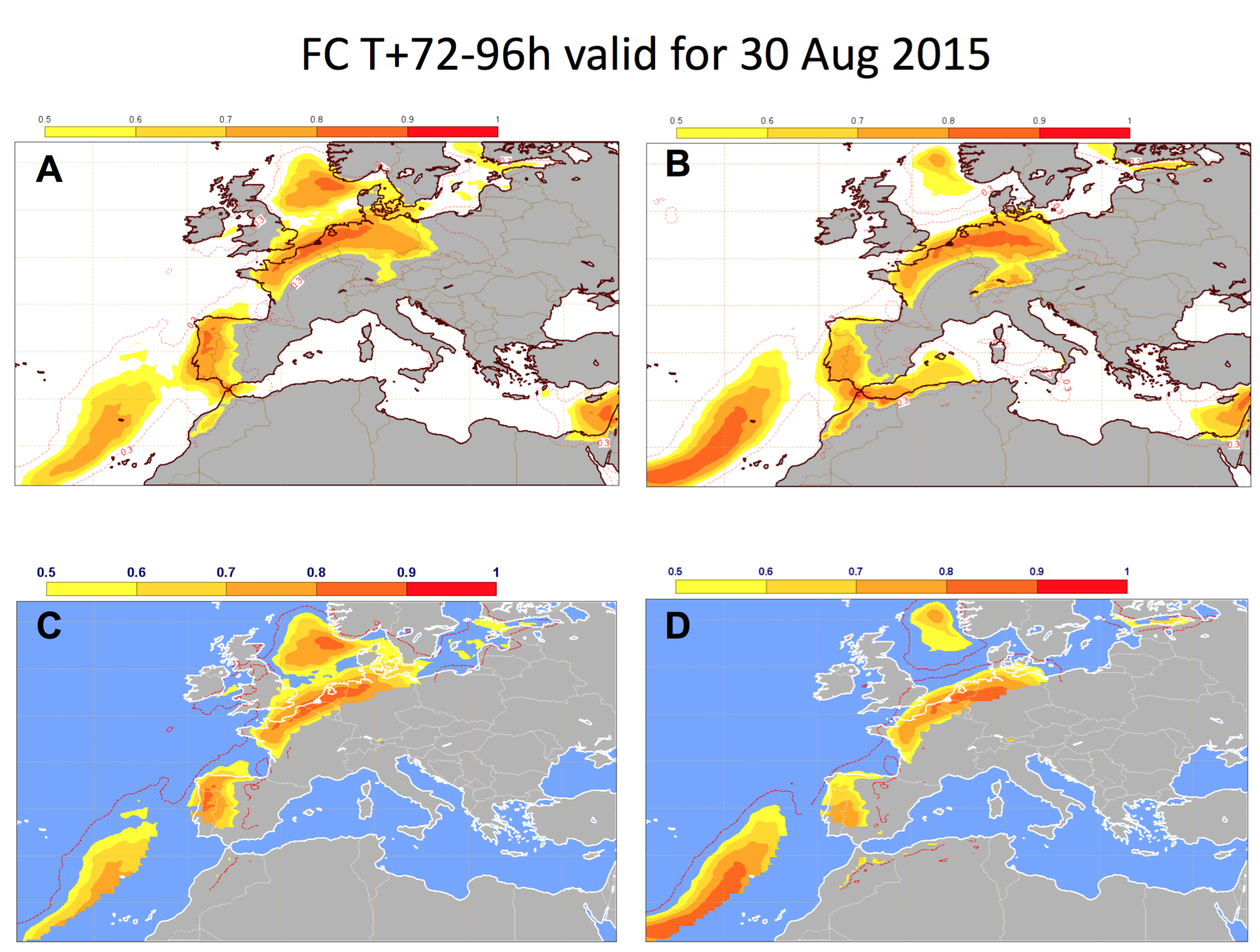
- The EFI fields for both CAPE and CSP show where severe convection is likely if it initiates. This means that in general high EFI values include also areas where DMC does not develop, for example because a capping inversion, as denoted by convective inhibition (CIN), is too strong. To help determine whether DMC will initiate or not one can employ also the probability forecast for precipitation (for example), in conjunction with the EFIs for CAPE and CSP (Figure 1).
- The EFI shows the extremity of a given parameter compared to the model climate. Hence high values of the EFI will sometimes be seen in areas where the absolute values of the convective parameters are relatively small This happens when even the extreme values of the convective parameters in the model climate are also relatively small, as might be seen over the continents in winter. In such a scenario one should not expect deep moist convection. Conversely a large CSP EFI would be particularly concerning if seen in an area and at a time where organised DMC was relatively common.
More information about CAPE and CSP can be found in the ECMWF Newsletter No.144 here (starts on page 27).
Further details and practical information about the EFI for CAPE and CSP are also available in the help section below the EFI web charts, in the sub-section entitled "EFI for CAPE and CAPESHEAR" here: real-time EFI-related products (select the CAPE or CAPESHEAR chart, then page down to see/open this subsection).
Figure 1. EFI forecasts for A) CSP; B) CAPE; C) CSP where probability of precipitation above 1mm/24h is greater than 5%; D) CAPE where probability of precipitation above 1mm/24h is greater than 5%. The EFI signal disappears over a large part of Germany except the northern areas after filtering out EFI values where probability of precipitation above 1 mm/24h is less than 5%. Severe convection developed only over the northern parts of Germany, whilst over the rest of the country it stayed dry and sunny.


