Page History
Table of Contents
Weather regimes
The large-scale air-flow over a region of the earth, which is governed by the height contour patterns, can be considered as inducing or controlling typical weather conditions in an area. The patterns are spatially fairly large, they affect the weather over regions as large as continents and have a persistence of typically ten days or more. These patterns over the Euro-Atlantic region may be described by a few weather regime definitions:
North Atlantic oscillation (NAO) regimes:
- +ve NAO (NAO+) have generally stronger pressure differences: Westerly winds predominate bringing mild, wet and stormy winter conditions to northern Europe and eastern USA while southern Europe is more likely to see cold, dry winter conditions.
- -ve NAO (NAO-) have generally weaker pressure differences: Spells of easterly winds bring cold dry and calm winters with fewer and weaker storms to northern Europe and eastern USA.
Blocking (BLO) regimes:
- +ve Blocking (BLO+) with ridging over Western Europe and Scandinavia: Spells of wintertime easterly winds bring increased occurrences of very cold and snowy weather to much of Europe while Scandinavia sees very cold, dry and calm conditions.
- -ve Blocking (BLO-) with ridging over the Atlantic: Spells of northerly winds bring increased occurrences of wintertime snow to western Europe while Central Europe is more likely to see very cold, dry and calm winters
The use of regimes allows increased predictability in the extended range, offsetting the decreasing predictability of synoptic features. Further, some probabilistic assessment may be made of the timing of transitions from one regime to another. There is some connection between weather regimes and surface weather and weather extremes. Specific regimes particularly provide the environmental conditions conducive to large-scale cold spells in winter, heat waves in summer, and widespread heavy precipitation or thunderstorm activity.
Schemes for identifying regimes
ECMWF currently displays extended range forecast data in regime format, based on Euro-Atlantic regimes, using two related schemes:
- 4-regime scheme. Shown as cumulative histograms using a four regime scheme (NAO+, NAO-, Blocking, ATR) where NAO denotes North Atlantic Oscillation, and ATR denotes Atlantic ridge. The signs show positive or negative characteristics. All regimes are independent of one another. There is also a fifth category of no (clearcutclear-cut) regime. This scheme is used to construct regime frequency histograms.
- Mirrored 2-regime scheme. Shown as phase-space diagrams using a two regime scheme ( NAO and BL) where NAO denotes North Atlantic Oscillation and BL denotes Blocking (both represented somewhat differently to the 4-regime scheme). Each has a negative and a positive component that are in both cases exactly opposite to one another; these are NAO+/- and BL+/-. There is also a fifth category of no (clearcutclear-cut) regime which would be denoted by the area close to the centre of the phase-space diagram. This scheme is used to construct to construct Phase Space or Regime Projection diagrams.
...
- 4-regime scheme is used to produce Regime Frequency Histograms in Extended Range Regime Charts.
- Mirrored 2-regime scheme is used to produce phase space diagrams in Medium Range Regime Charts and Extended Range Regime Charts.
Regime assignment of forecast data is in each case computed in Empirical Orthogonal Function (EOF) space using "calibrated" anomalies of 500mb height/geopotential. These
In order to achieve regime assignment:
- first the anomalies are computed with respect to the re-forecast 20-year climate (ER-M-climate)
...
- .
- then those anomalies are compared with reference points for the regime definitions
...
- . The regime definitions are themselves based on re-analysis data.
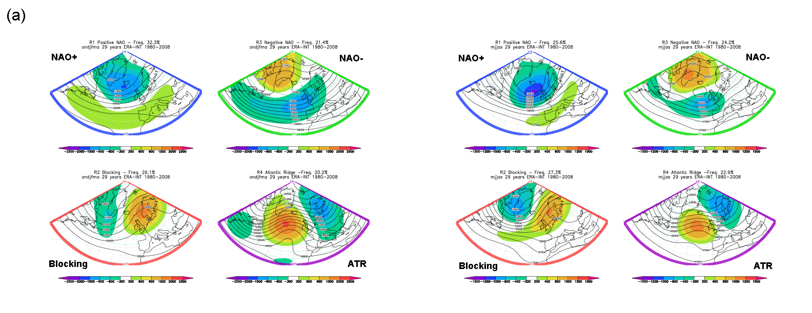
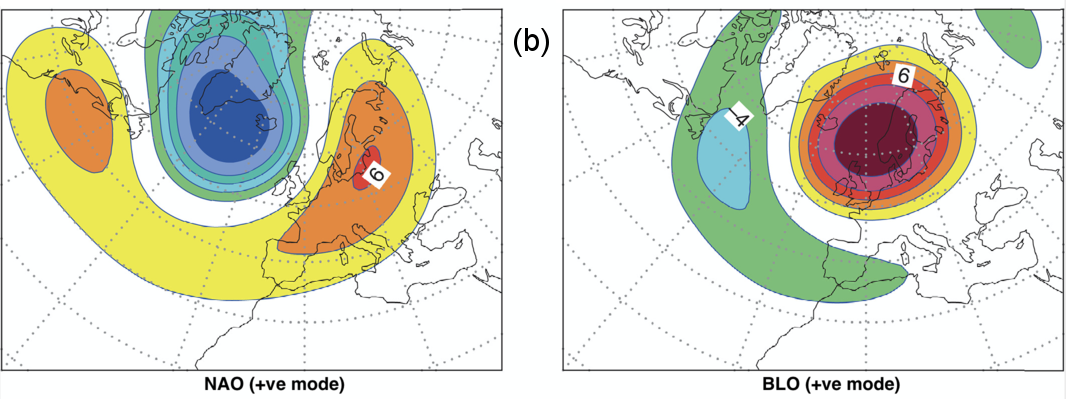
Fig7.4-1 and Fig7.4-2 ) in order to achieve regime assignment. Fig8.1.15.1A and Fig8.1.15.1B show what these regime reference points look like in 500mb anomaly space for the two schemes. These are for illustrative purposes only – the user should not expect a model forecast assigned to a particular regime to look exactly like these; ordinarily there will just be some vague resemblance.
For the 4-regime scheme, whilst two sets of anomalies are shown, in reality the reference points against which forecast anomalies are compared actually vary smoothly through the year. This is done by giving different weights to these patterns depending upon the month. So The reference points for forecasts for the main months of winter and of summer the reference points will be almost summer months are almost identical to that shown in , respectively, the left and right sets in Fig8.1.15.1A, whilst for Fig7.4-1. For intermediate month forecasts they will be a weighted combination.
...
Fig8.1.15.1BFig7.4-2: Diagrams depict the Euro-Atlantic sector around which the regime definitions used in ECMWF products are based.
...
The use of regimes can be explored at medium range regime charts and extended range regime charts.
Read more about the use of "Weather regimes" at ECMWF (2020 article)
...

